The Lake District
England's biggest national park: the high fells, sixteen lakes and the valley villages from Keswick and Ambleside to Coniston, Wasdale and Ullswater.
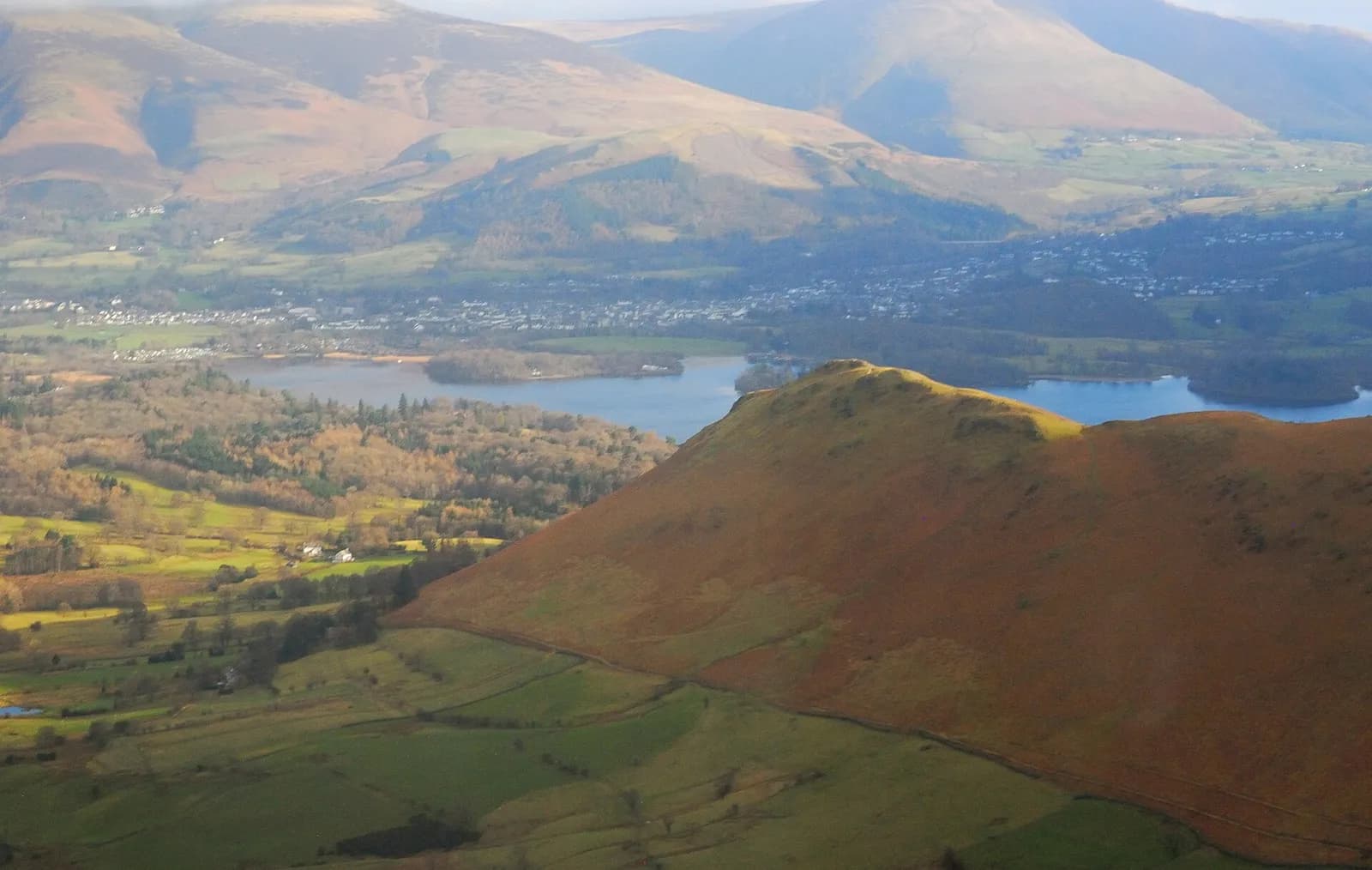
The Lake District is the mountain heart of Cumbria and the reason most people come. On this site it means the Lake District National Park and its gateway towns: Keswick in the north, Ambleside, Grasmere and Windermere in the middle, Coniston and Hawkshead to the south west, Glenridding and Pooley Bridge on Ullswater, and the quieter western valleys of Buttermere, Ennerdale, Wasdale and Eskdale. Kendal sits just outside the boundary but works as its southern market town, and Caldbeck covers the northern fells, the area locals call Back o' Skiddaw.
It is the largest national park in England and has been a UNESCO World Heritage Site since 2017, recognised as a cultural landscape shaped by fell farming as much as by poets. Scafell Pike, the highest mountain in England, rises above Wasdale, and Helvellyn is climbed from Glenridding. The lakes themselves run from Windermere, the largest natural lake in England, down to tiny Elter Water.
What it is best for depends on where you stand. The central corridor along the A591 has the trains, the buses, the boats and the busiest cafes. The west has the big walking, the single track roads and very little else. Spring and autumn are the sweet spots: longer light than winter, fewer cars than August, and the bracken turning copper from late September.
The honest downside is that the popular places are very popular. Car parks at Catbells, Glenridding, Buttermere and the Langdales fill early on fine summer weekends, and the lanes are narrow. Weather moves quickly over the fells, and the western valleys are among the wettest places in England. Use the buses where you can, start early, and always carry a waterproof.
Walks in The Lake District
All walks in The Lake DistrictAira Force waterfall loop
Easy, 1.5 km, 50 m up, about 30 minutes
A short woodland loop on National Trust land above Ullswater to the foot and top of Aira Force, one of the Lakes' best known waterfalls.
Alcock Tarn from Grasmere
Moderate, 5.4 km, 312 m up, about 1 hour 30 minutes
A short, steep climb from Grasmere to a quiet fellside tarn, with one of the best views of the vale on the way down past Dove Cottage.
Blencathra via Sharp Edge from Scales
Mountain, 9.4 km, 840 m up, about 3 hours 30 minutes
The Lake District's sharpest ridge: up from Scales to Scales Tarn, along the knife edge of Sharp Edge to Blencathra's summit, and down Scales Fell.
Borrowdale valley loop: Seatoller, Rosthwaite and Stonethwaite
Easy, 7.6 km, 199 m up, about 2 hours
A low-level ramble through the heart of Borrowdale: Johnny Wood, the River Derwent, Rosthwaite and the quiet side valley to Stonethwaite.
Bowfell from the Old Dungeon Ghyll via The Band and Three Tarns
Hard, 13.1 km, 844 m up, about 4 hours
The classic Langdale round: up The Band to Three Tarns, a rocky climb to Bowfell's summit, then down by Ore Gap, Angle Tarn and Rossett Gill to Mickleden.
Brant Fell from Bowness
Easy, 5.6 km, 175 m up, about 1 hour 30 minutes
A short loop from Bowness over Post Knott to the rocky top of Brant Fell, with one of the best views over Windermere, returning on the Dales Way.
Buttermere lake circuit
Easy, 8.8 km, 122 m up, about 2 hours
A level walk all the way round Buttermere, with a lakeshore tunnel, a beach at the head of the lake and the High Stile ridge towering above.
Carron Crag trail, Grizedale Forest
Moderate, 8.3 km, 257 m up, about 2 hours
Grizedale's purple waymarked trail from the visitor centre to Carron Crag, the forest's highest point, with views to the Coniston fells.
Castle Crag from Grange
Moderate, 6.2 km, 279 m up, about 1 hour 30 minutes
The smallest Wainwright with the biggest personality: up through old slate workings to Castle Crag's summit memorial, then down past Millican Dalton's cave.
Castlerigg Stone Circle from Keswick
Easy, 6.3 km, 130 m up, about 1 hour 30 minutes
An easy walk from Keswick to Castlerigg, the stone circle ringed by fells, out along the old railway line and lanes and back through farmland.
Catbells from Gutherscale
Moderate, 7.1 km, 422 m up, about 2 hours
Keswick's favourite little fell: up the north ridge of Catbells to a rocky top over Derwentwater, down from Hause Gate and back along the terrace path.
Causey Pike and Scar Crags from Stoneycroft
Hard, 8.7 km, 678 m up, about 3 hours
Newlands' best short ridge: up the rocky steps of Rowling End to the knobbly top of Causey Pike, along to Scar Crags, and back past the old Stoneycroft mines.
Dodd from Dodd Wood (Old Sawmill)
Moderate, 5.0 km, 382 m up, about 1 hour 30 minutes
A steep woodland climb from the Old Sawmill to a summit with a view over Bassenthwaite Lake, Derwentwater and across the Solway to Scotland.
Dunmallard Hill from Pooley Bridge
Easy, 2.1 km, 111 m up, about 30 minutes
A short woodland loop from Pooley Bridge over the wooded knoll at the foot of Ullswater, with the remains of an Iron Age fort on top.
Easedale Tarn from Grasmere
Moderate, 8.6 km, 227 m up, about 2 hours
Grasmere's classic tarn walk: up beside the white cascades of Sourmilk Gill to a big mountain tarn, back by Far Easedale.
Elterwater to Skelwith Force
Easy, 5.4 km, 36 m up, about 1 hour
A level riverside walk from Elterwater village, past the lake and through meadows to the falls at Skelwith Force. No stiles.
Friar's Crag and the Derwentwater shore from Keswick
Easy, 3.2 km, 6 m up, about 30 minutes
Keswick's favourite short stroll: from Theatre by the Lake to the Friar's Crag viewpoint, then on along the shore and boardwalk. Mostly step-free.
Great Gable from Honister via Moses' Trod
Hard, 9.7 km, 822 m up, about 3 hours 30 minutes
A big-mountain day from a high start: out along the old smugglers' track of Moses' Trod to Beck Head, up Great Gable, and home over Green Gable, Brandreth and Grey Knotts.
Grisedale Pike and Hopegill Head from Braithwaite
Hard, 12.5 km, 855 m up, about 4 hours
Braithwaite's big fell: straight up the ridge to Grisedale Pike, along the rim of Hobcarton Crag to Hopegill Head, and back down Coledale past the old Force Crag Mine.
Gummer's How above Windermere
Easy, 2.0 km, 115 m up, about 30 minutes
The quickest big view of Windermere: a short climb from a free Forestry England car park to a trig point looking up the whole length of the lake.
Hallin Fell and the Ullswater shore from Martindale
Moderate, 5.0 km, 266 m up, about 1 hour 30 minutes
Ullswater's best small fell: a 20-minute pull to a huge summit cairn, then a loop round the wooded shore past Kailpot Crag.
Haystacks from Gatesgarth
Hard, 7.7 km, 529 m up, about 2 hours 30 minutes
A small fell with a big character: from Gatesgarth over Scarth Gap to the craggy top of Haystacks, past Innominate Tarn and down Warnscale.
Helm Crag from Grasmere
Moderate, 6.6 km, 326 m up, about 2 hours
Grasmere's own fell: a short, steep climb from Easedale to the rocky crest known as the Lion and the Lamb, with an exposed summit block for those who want it.
Helvellyn by the Pony Path from Glenridding
Hard, 20.4 km, 1132 m up, about 6 hours
Helvellyn without the scrambles: up the old pony path from Glenridding via Keppel Cove, along the summit ridge to Dollywaggon Pike and home down Grisedale.
Helvellyn via Striding Edge and Swirral Edge
Mountain, 13.3 km, 955 m up, about 4 hours 30 minutes
England's most famous ridge scramble: from Glenridding over the knife edge of Striding Edge to Helvellyn, then down Swirral Edge past Red Tarn.
High Street from Mardale Head via Rough Crag
Hard, 9.6 km, 632 m up, about 3 hours
High Street's finest side: up the long ridge of Rough Crag and Long Stile above Haweswater, then down by Mardale Ill Bell, Nan Bield Pass and Small Water.
Latrigg from Keswick
Moderate, 4.9 km, 292 m up, about 1 hour 30 minutes
Keswick's own small fell: up Spooney Green Lane and the zigzags to a grassy top with one of the finest views of Derwentwater in the Lakes.
Lingmoor Fell and Side Pike from Elterwater
Moderate, 11.6 km, 536 m up, about 3 hours
A small fell with a huge view: from Elterwater through old slate quarries to Lingmoor's ridge, over Side Pike above Blea Tarn, and back along Great Langdale.
Loughrigg Fell from Ambleside
Moderate, 10.2 km, 413 m up, about 2 hours 30 minutes
Ambleside's own fell: over the knobbly top of Loughrigg, along Loughrigg Terrace above Grasmere, past Rydal Cave and home by the River Rothay.
Loweswater and Holme Wood from Maggie's Bridge
Easy, 3.8 km, 5 m up, about 1 hour
A level, fully accessible walk along the quiet south shore of Loweswater into the oaks of Holme Wood. A Miles without Stiles route for all.
Orrest Head from Windermere station
Easy, 2.5 km, 108 m up, about 30 minutes
A short climb straight from Windermere station through woodland to Orrest Head, a 360 degree viewpoint over Windermere and the central fells.
Place Fell from Patterdale
Moderate, 7.6 km, 542 m up, about 2 hours 30 minutes
The best viewpoint over Ullswater for the effort: up from Patterdale to Boredale Hause and Place Fell, then down by The Knight to the lakeshore path.
Rannerdale Knotts and the bluebell valley
Moderate, 5.3 km, 356 m up, about 1 hour 30 minutes
A small fell with a big view over Crummock Water, climbed via Rannerdale, the valley famous for its May carpet of bluebells.
Red Pike, High Stile and High Crag from Buttermere
Hard, 14.1 km, 839 m up, about 4 hours
One of Lakeland's great ridge walks: up past Bleaberry Tarn to Red Pike, along the crags to High Stile and High Crag, then down Gamlin End to Scarth Gap and the lake.
Rydal Water and Rydal Cave from Pelter Bridge
Easy, 6.8 km, 231 m up, about 1 hour 30 minutes
A full circuit of Rydal Water: the old Coffin Route, the River Rothay to Grasmere, Loughrigg Terrace and the great slate cavern of Rydal Cave.
Scafell Pike from Wasdale Head
Mountain, 8.7 km, 969 m up, about 3 hours 30 minutes
The shortest way up England's highest mountain: from the head of Wastwater by Lingmell Gill and Brown Tongue to the summit of Scafell Pike.
Scout Scar and Cunswick Scar from Kendal
Moderate, 10.3 km, 260 m up, about 2 hours 30 minutes
Kendal's doorstep classic: over Kendal Fell to the limestone edges of Cunswick Scar and Scout Scar, with the whole Lake District skyline from the Mushroom.
Silver How from Grasmere
Moderate, 5.8 km, 370 m up, about 2 hours
Grasmere's own little fell: a short circuit to a rocky summit with one of the finest views of the vale, the lake and the Langdale Pikes.
Skiddaw from the Latrigg car park (Gale Road)
Hard, 10.7 km, 755 m up, about 3 hours 30 minutes
The quickest honest way up Skiddaw: the old pony track from the top of Gale Road, up Jenkin Hill and along the stony summit ridge to the trig point.
Stickle Tarn from the New Dungeon Ghyll
Moderate, 3.2 km, 379 m up, about 1 hour 30 minutes
The best short climb in Great Langdale: up the tumbling Stickle Ghyll from the New Dungeon Ghyll to Stickle Tarn under the cliffs of Pavey Ark.
Tarn Hows circular walk
Easy, 3.0 km, 38 m up, about 30 minutes
An easy loop on a good path around Tarn Hows, the wooded tarn between Coniston and Hawkshead with the Langdale and Coniston fells behind.
The Fairfield Horseshoe from Ambleside
Hard, 19.5 km, 1018 m up, about 5 hours 30 minutes
One of the great Lakeland rounds: from Ambleside up Nab Scar and over eight tops around the Rydal valley, with Fairfield's summit at the head.
The Kentmere Horseshoe
Hard, 21.2 km, 1157 m up, about 6 hours
A long, classic round of nine Wainwrights from Kentmere: up the Garburn Road to Yoke and Ill Bell, over High Street, and home by Harter Fell and Shipman Knotts.
The Old Man of Coniston via the Coppermines and Walna Scar
Hard, 11.7 km, 772 m up, about 3 hours 30 minutes
Coniston's mountain by its most interesting line: up through the old copper and slate workings to Low Water and the summit, down by Goat's Water and Walna Scar.
Ullswater Way: Howtown to Glenridding
Moderate, 11.3 km, 317 m up, about 3 hours
A favourite low-level Lakes walk: steamer to Howtown, then home along the wild eastern shore of Ullswater to Glenridding.
Walla Crag from Keswick
Moderate, 10.6 km, 377 m up, about 2 hours 30 minutes
A half-day round from Keswick over Castlehead to the cliff-top of Walla Crag, down to Ashness Bridge and home along the Derwentwater shore.
Wansfell Pike and Troutbeck from Ambleside
Hard, 11.6 km, 602 m up, about 3 hours 30 minutes
Ambleside's own fell: past Stock Ghyll Force to Wansfell Pike, down Nanny Lane to Troutbeck, home through Skelghyll Woods and Jenkin Crag.
Towns, villages and lakes in The Lake District
- Keswick
The northern Lakes' busiest town: Derwentwater at the end of the street, Skiddaw behind, a twice weekly market and the best base for the fells.
- Ambleside
A walkers' town at the head of Windermere, with Bridge House, Stock Ghyll Force, the Armitt museum and fells on three sides.
- Windermere
The railway town above the lake: the end of the Lakes Line, the climb to Orrest Head and the start point for Bowness, Brockhole and the boats.
- Bowness-on-Windermere
Windermere's lakeside resort: boats from Bowness Bay, the Jetty Museum, Beatrix Potter's world and the ferry across to Far Sawrey.
- Grasmere
Wordsworth's village: Dove Cottage, the churchyard at St Oswald's, the famous gingerbread and fell walks to Helm Crag and Easedale Tarn.
- Coniston
A former copper mining village under the Old Man of Coniston, with the Ruskin Museum, boats to Brantwood and a lake of speed records.
- Hawkshead
A largely car free village of whitewashed lanes between Windermere and Coniston, with Beatrix Potter connections and Wordsworth's old school.
- Kendal
The Auld Grey Town: south Cumbria's market town, with a ruined castle, historic yards, Kendal Mint Cake and the gateway to the Lakes.
- Borrowdale
The valley south of Keswick: Rosthwaite, Grange, Seatoller and Seathwaite, the Bowder Stone, Castle Crag and the way up Scafell Pike.
- Glenridding
The village at the head of Ullswater: start of the Helvellyn climbs, the Ullswater 'Steamers' pier and the old Greenside mine.
- Pooley Bridge
The village at the foot of Ullswater, with its new steel bridge, the Steamers pier, Dunmallard Hill and quiet fells to the south.
- Buttermere
A tiny village between Buttermere and Crummock Water: the lake circuit, Haystacks, Scale Force and two passes to drive over.
- Wasdale
The wildest valley in the Lakes: Wastwater, England's deepest lake, its screes, and Wasdale Head under Scafell Pike and Great Gable.
- Langdale
Great Langdale: the Langdale Pikes, Stickle Tarn, the Dungeon Ghyll hotels and the villages of Elterwater and Chapel Stile.
- Braithwaite
A fellside village two miles west of Keswick, at the foot of Whinlatter Pass and the Coledale Horseshoe, with two good pubs.
- Staveley
A riverside village between Kendal and Windermere with its own station, the busy Mill Yard and the quiet Kentmere valley beyond.
- Eskdale
A green western valley reached by the narrow gauge Ravenglass and Eskdale Railway, with Boot, Hardknott Roman Fort and Stanley Force.
- Caldbeck
A pretty village on the northern edge of the fells: John Peel's grave, Priest's Mill, the Howk gorge and the Cumbria Way.
- Windermere
England's largest natural lake: 18 km of water from Ambleside to Lakeside, with cruises, the car ferry, islands and lakeshore houses.
- Ullswater
The second largest lake, a long dog leg from Pooley Bridge to Glenridding under Helvellyn, with the Steamers, Aira Force and the Ullswater Way.
- Derwentwater
Keswick's lake: wooded islands, the Keswick Launch, Friar's Crag and Catbells above the western shore, at the mouth of Borrowdale.
- Coniston Water
A long, quiet lake under the Old Man of Coniston: Ruskin's Brantwood, the Steam Yacht Gondola, Peel Island and speed record history.
- Bassenthwaite Lake
The only lake in the Lake District with 'lake' in its name: a quiet, shallow nature reserve under Skiddaw, famous for its ospreys.
- Haweswater
A remote reservoir in the eastern fells that drowned the village of Mardale, now a quiet haven for walkers and wildlife.
- Thirlmere
A Victorian reservoir under Helvellyn's western slopes, ringed by forest, with quiet shore paths and the A591 alongside.
- Ennerdale Water
The most westerly lake and the only one with no public road along it: wild, quiet and the gateway to Pillar and the Wild Ennerdale project.
- Wastwater
England's deepest lake, under the plunging Screes, with Britain's favourite view up to Great Gable and Scafell Pike at its head.
- Crummock Water
Buttermere's larger neighbour: a big, quiet lake between Grasmoor and Mellbreak, with Scale Force and fine shore walks.
- Buttermere
A small lake under High Stile and Haystacks, with one of the best low level walks in England right round its shore.
- Loweswater
A small, gentle lake in the north western fells, with woodland walks through Holme Wood and the Kirkstile Inn nearby.
- Grasmere
Wordsworth's small lake below Grasmere village, with a wooded island, a shingle beach and Loughrigg Terrace above.
- Rydal Water
One of the smallest lakes, between Ambleside and Grasmere, with Rydal Cave, Wordsworth's Rydal Mount and the Coffin Route.
- Esthwaite Water
A small, quiet lake by Hawkshead in Beatrix Potter's countryside, known for its fishing and Wordsworth's boyhood rambles.
- Elter Water
A tiny, reedy lake at the mouth of Langdale with a classic view to the Langdale Pikes and an easy riverside path to Skelwith Force.