Guides · 21 October 2026
The best views in the Lake District: 10 viewpoints and how to reach them
By Only Cumbria, updated 21 October 2026, 7 minute read
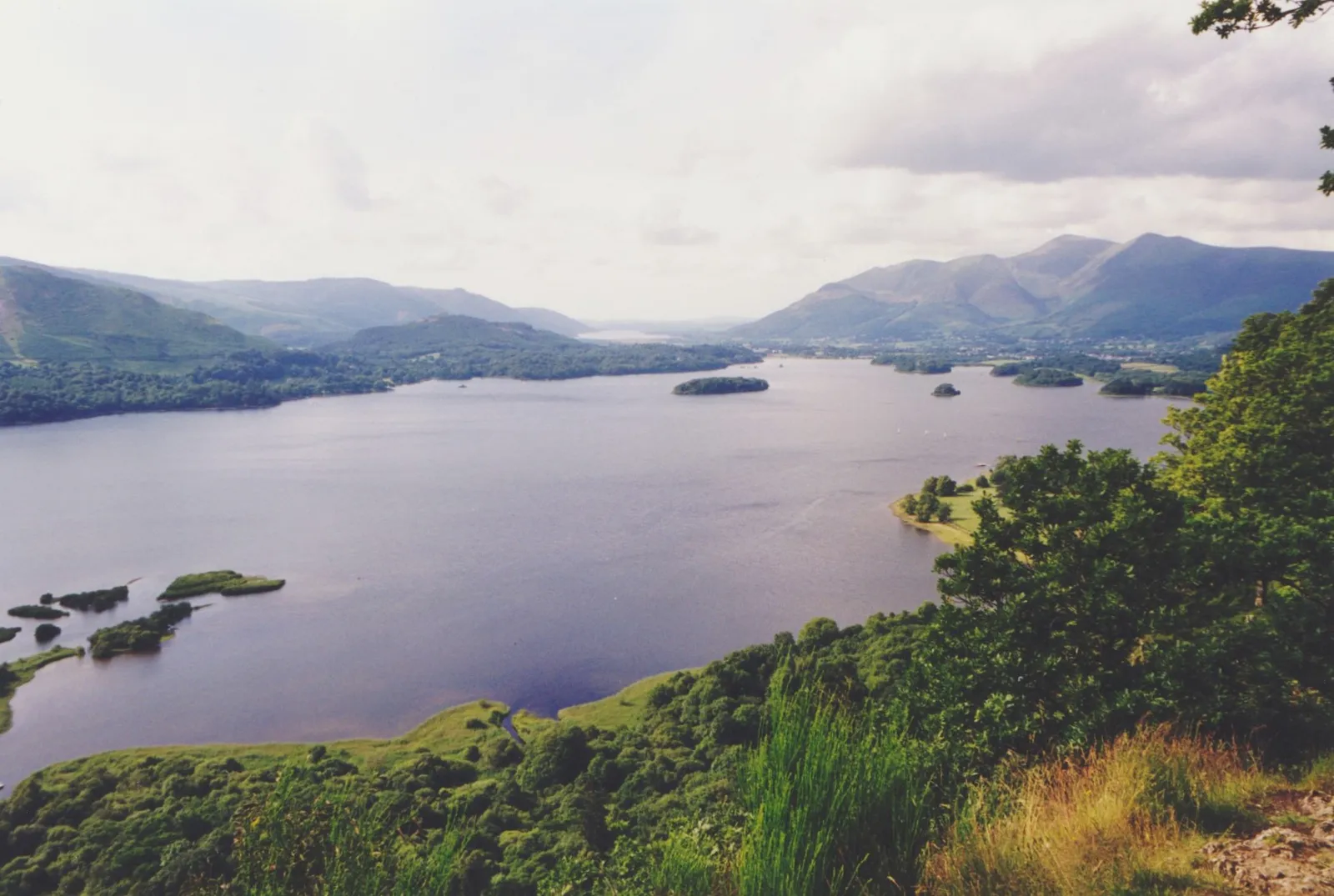
The best Lake District views are rarely from the highest summits. Some of the finest are from small fells you can climb before lunch, and a couple are a few steps from a car park. We have picked ten that we think earn their place, ordered roughly from least to most effort, and for each one we say how to get there and which of our walks to follow. Three more outside the National Park follow at the end.
1. Surprise View, above Derwentwater
The easiest big view in the Lakes. Surprise View sits at the top of the crags on the narrow lane that climbs from the Derwentwater shore road towards Watendlath, a little above Ashness Bridge. From the edge you look down over the whole of Derwentwater and across to Keswick and Skiddaw.
How to reach it: take the B5289 south from Keswick, turn off on the Watendlath road and climb past Ashness Bridge. There are two small National Trust car parks on the lane, one at the bridge and one higher up at Surprise View. The road is steep and single track with passing places, so take it slowly. Without a car, the Keswick Launch calls at Ashness Gate, and Visit Keswick puts the walk up the lane to the bridge at about 20 minutes, with a short further climb to the viewpoint. Ashness Bridge itself, a little stone packhorse bridge with Skiddaw behind, is the classic photograph on the way. Our Walla Crag walk from Keswick also passes it.
2. Friar's Crag, Keswick
A rocky little point at the north end of Derwentwater, about ten minutes from Keswick on foot. The view runs down the lake past the wooded islands to the Jaws of Borrowdale. It is on a Miles without Stiles route from Theatre by the Lake, so it is one of the few great views that works for pushchairs and many wheelchair users. Follow our Friar's Crag walk and park at the Lakeside car park. See our accessible guide for more step-free options.
3. Orrest Head, Windermere
The fell that started it all for Alfred Wainwright. He climbed Orrest Head straight from Windermere station on his first visit to the Lakes in 1930, and it is the first fell he climbed in Lakeland. The National Park describes a 360 degree view over Windermere and the central fells from the top, where benches are set around a compass marker.
How to reach it: the path starts a few minutes from Windermere station, and the National Park suggests about an hour for the walk. Follow our Orrest Head walk; drivers can use the Broad Street car park, which has public toilets. It is an obvious one for a car-free visit.
4. Latrigg, Keswick
Latrigg is the rounded fell behind Keswick, and the bench on its top looks straight down Derwentwater into Borrowdale. On a good day the National Park notes Scafell Pike, Great End and Great Gable at the head of the valley, with Helvellyn to the left. It is a classic sunset walk.
How to reach it: walk it from town with our Latrigg walk, starting from the Crosthwaite Road car park. For a much shorter approach, the National Park's Miles without Stiles route starts from the car park at the head of Gale Road (CA12 4PH) and takes about half an hour, although the first stretch is steep.
5. Gummer's How, south Windermere
At 321 metres, Gummer's How is a small fell with one of the longest lake views in the district: from the trig point you look up the full length of Windermere towards the Langdale Pikes. The climb is short because the start is already well up the hillside.
How to reach it: the usual start is the small, free Forestry England car park on the minor road that climbs above the south end of the lake, not a layby on the A592. It fills quickly in season. From there it is about 130 metres of ascent on a good path. Follow our Gummer's How walk and see the car park page.
6. Loughrigg Terrace and Loughrigg Fell
Loughrigg is the knobbly fell between Ambleside, Grasmere and Langdale, and its summit view takes in Grasmere, Rydal Water and Windermere with a long line of central fells behind. Lower down, Loughrigg Terrace is a level path along its flank with the classic view down onto Grasmere lake.
How to reach it: our Loughrigg Fell walk is a full round from Ambleside's Miller Bridge car park, over the top, along the terrace and past Rydal Cave. For a shorter outing, Mud and Routes recommends the White Moss Common car park between Grasmere and Rydal Water as a starting point. Our Rydal Water walk covers the lower ground.
7. Tarn Hows, between Coniston and Hawkshead
Tarn Hows looks entirely natural, but it is largely man-made. It was once three smaller tarns, and the Marshall family, who owned the land, dammed the lowest to create the single sheet of water you see today, and planted the conifers around it. Beatrix Potter later bought the estate, and it passed to the National Trust. The fells behind make it one of the most photographed scenes in the Lakes, especially in autumn.
How to reach it: use the National Trust Tarn Hows car park, with a separate disabled parking area closer to the tarn. Follow our Tarn Hows walk, an easy loop on a broad surfaced path.
8. Hallin Fell, Ullswater
Hallin Fell is surrounded on three sides by Ullswater, on the far side of the lake from Glenridding, and from its tall square summit cairn the view takes in Ullswater, Helvellyn, High Street and Blencathra. For the effort it may be the best value view in the National Park.
How to reach it: drive from Pooley Bridge through Howtown and up the steep, narrow road to St Peter's Church at Martindale, where there is a small free car park; the summit is about 20 minutes away. Follow our Hallin Fell walk, which adds a loop along the shore, and see the car park page.
9. Haystacks, Buttermere
Wainwright's favourite summit, which he called "the best fell-top of all". At 597 metres it is modest, but it is a tangle of crags and little tarns with Buttermere and Crummock Water below and Great Gable and Pillar close by. Innominate Tarn, where his ashes were scattered, sits along the summit ridge, and long, narrow Blackbeck Tarn lies at its eastern end. Older guides sometimes place Blackbeck Tarn in Langdale. It is on Haystacks, above Buttermere.
How to reach it: start from the Gatesgarth Farm car park at the foot of Honister Pass, a private car park that a third-party guide reports takes coins only. Follow our Haystacks walk over Scarth Gap and back by Warnscale. The ground is rough and there are a few easy scrambly moments.
10. Helvellyn
At 950 metres, Helvellyn is the third-highest mountain in England, and on a clear day dozens of Wainwright fells are visible from its broad summit plateau. The approach over Striding Edge, a rocky crest more than 1.5 km long, is the most famous ridge walk in the Lakes.
How to reach it: this is a serious mountain day. Our Striding Edge walk starts from the Glenridding car park and returns by Swirral Edge. For a route without scrambling, see Helvellyn via the Pony Path. Wikipedia notes several walkers have died on Striding Edge, and in winter ice and cornices make it dangerous without an ice axe and crampons. Check the Mountain Weather Information Service (MWIS) forecast first.
Two more fells worth the climb
- Rannerdale Knotts, Crummock Water. A small rocky ridge right above Crummock Water with the Buttermere fells stacked behind, reached through a side valley known for its bluebells in May. Follow our Rannerdale Knotts walk from the Rannerdale car park, which fills fast in bluebell season.
- Wansfell Pike, Ambleside. The steep fell behind Ambleside, with a view down the length of Windermere. The usual line climbs from town past Stock Ghyll Force. Follow our Wansfell Pike walk.
Beyond the National Park
- Scout Scar, Kendal. A limestone edge above the Lyth Valley looking across to Coniston Old Man, Bowfell and the Langdale Pikes. The short National Park route starts from a car park about 2.5 km up Allhallows Lane from Kendal Town Hall, or walk it from town with our Scout Scar walk.
- Ruskin's View, Kirkby Lonsdale. The view over the River Lune from St Mary's churchyard, painted by Turner and named after John Ruskin, who called it one of the loveliest in England. Our Devil's Bridge walk takes it in.
- Arnside Knott. A limestone hill where the Kent estuary meets Morecambe Bay, with a toposcope near the top. See our Arnside Knott walk.
Before you go
- Weather: a view needs clear air. Check a mountain forecast such as MWIS before any fell, and keep the valley viewpoints for days when the tops are in cloud.
- Parking: most of these car parks are small and fill early on fine weekends. Arrive early or late, carry coins as a backup, and check charges on the operator's signs. Our parking guide has more.
- Time of day: early mornings and evenings are quieter at every one of these. If you stay on a fell for sunset, take a torch for the way down.
- Kit: even short fells are steep and exposed. Boots, a waterproof and a warm layer are worth carrying on anything beyond Friar's Crag and Surprise View.
- More ideas: see our things to do and rainy day guides.